Trail Walking La Bruyère - Bovesse 020424 - Photo
© OpenStreetMap contributors
Length
Length
15.3 km
Max alt
Max alt
193 m
Uphill gradient
Uphill gradient
130 m
Km-Effort
Km-Effort  
17 km
Min alt
Min alt
142 m
Downhill gradient
Downhill gradient
130 m
Boucle
Boucle
Yes
Creation date :
2024-04-02 08:15:31.012
Updated on :
2024-04-02 12:12:02.188

(0 Reviews)

Walking
Walking
3h40
Difficulty : Medium

Scan this QR Code to open this trail in the SityTrail application

FREE GPS app for hiking

Logo SityTrail SityTrail

IGN / Geographical institutes

Download SityTrail from the App Store Download SityTrail from Google Play

Logo SityTrail SityTrail Plus

The world is yours!

Download SityTrail from the App Store Download SityTrail from Google Play Download SityTrail on Huawei AppGallery

About

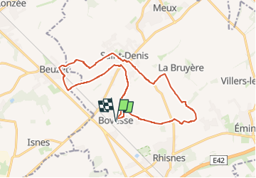
Trail Walking of 15.3 km to be discovered at Wallonia, Namur, La Bruyère. This trail is proposed by guyernage25.

Description

Balade campagnarde.
ATTENTION, à  Beuzet ne pas traverser la voie de chemin de fer prendre la rue Sergent Collin et aller toujours tout droit jusqu au verger.
Après ce verger (grande exploitation) et au delà du petit bosquet, ne pas prendre à droite car chemin privé.  Donc continuer la Ruelle Procès jusque St Denis

Elevation profile

Photos

Positioning

Country:
Belgium
Region :
Wallonia
Department/Province :
Namur
Municipality :
La Bruyère
Location:
Unknown
Start:(UTM)
626073 ; 5597614 (31U) N.


Close
My subscriptions